Endangered Species Recovery Program | |
|
Home | News | Publications | Species profiles | Data and maps | About | Staff | Links | Department of Biological Sciences | CSU Stanislaus |
I. INTRODUCTION
A. Background
Vast tracts of land on the west side of the San Joaquin Valley are characterized by a high groundwater level and high selenium content. The application of irrigation water to these lands results in an accumulation of poor-quality drain-water. The elimination of drain water is a chronic problem on these lands. One way to reduce the accumulation of drain water and to lessen problems associated with its disposal is to retire the land from agricultural production. The Central Valley Project Improvement Act (CVPIA) of 1992 4 authorized a land retirement program as recommended in the San Joaquin Valley Drainage Program Final Report 5 . An interagency team consisting of representatives from the United States Bureau of Reclamation (USBR), the United States Fish and Wildlife Service (USFWS), and the United States Bureau of Land Management (USBLM) has been assembled to accomplish the goals of the CVPIA Land Retirement Program 6 . Although land retirement may provide solutions to some problems associated with agricultural drainwater, land retirement comes with its own set of challenges. Some of these include: land acquisition, redistribution of the acquired water, and habitat restoration to reduce the potential for agricultural weeds and pests that would adversely impact neighboring farming interests.
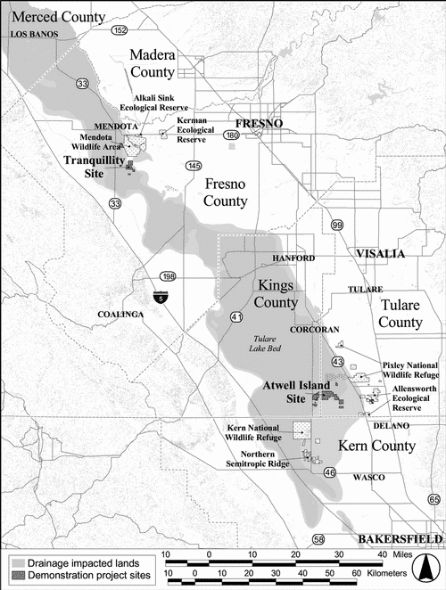
The Land Retirement Team (LRT) is entrusted with the task of implementing the CVPIA Land Retirement Program. Through this program, the United States Department of Interior (USDOI) may purchase land, water, and other property interests from willing sellers who receive Central Valley Project (CVP) water allocations and are located in areas where there are significant drainage problems (Figure 1). Condemnation of land is not a part of this program. However, willing sellers are numerous because of the low productivity and high cost of agricultural production on drainage impaired lands.
The broad goals of the Land Retirement Program are to:
- Reduce the volume of drain water by retiring lands from irrigated agricultural production on the west side of the Valley,
- Acquire water for CVPIA purposes, and
- Enhance fish and wildlife resources.
4,5,6Additional background information on the CVPIA Land Retirement Program can be found in a variety of reports (USDI 1997, USDI 1999, Selmon et al. 2000, Uptain et al. 2001) and web sites (see http://www.mp.usbr.gov/mp/cvpia).

Figure 1.
Drainage impacted lands in the San Joaquin Valley.
B. Development of the Land Retirement Demonstration Project
During the comment period for the Land Retirement Program Draft Environmental Assessment (EA), concerns were raised about the magnitude of the project and the lack of knowledge about the potential positive and negative effects of retirement of agricultural land on a large scale (USDI 1999). The Land Retirement Demonstration Project (LRDP) was initiated to address concerns about the scope and degree of impacts of retirement on wildlife, drainage volume reduction, socio-economics, and overall cumulative effects of removal of land from irrigated agriculture.
Specifically, the goals of the Land Retirement Demonstration Project are to:
- Provide site-specific scientific data to determine if land retirement is an effective way to reduce drain water volume and provide habitat. Results will guide implementation of the larger Land Retirement Program;
- Research cost-effective means of restoring self-sustaining communities of native upland plants and animals on LRDP lands that will be applicable to larger acreages;
- Use adaptive management principles (Holling 1978, Walters and Holling 1990) to maximize efficiency of the restoration research program;
- Educate stakeholders about the Land Retirement Program; and
- Evaluate the need for continued use of acquired water on Demonstration Project lands. If not needed for habitat restoration or continued management of these lands, USDI may sell the water to another user within the water district or the water may be used for other CVPIA purposes (USDI 1999).
A resource monitoring plan was prepared by the California State University Stanislaus, Endangered Species Recovery Program (ESRP). That plan outlined habitat restoration research and protocols to monitor for potential contamination of wildlife resulting from the high selenium levels in shallow groundwater, soils, and surface accumulation of water (Selmon et al. 1999). The research and monitoring described in that plan were implemented in 1999. A separate monitoring plan was also prepared that describes sampling and analysis of physical factors including surface water, groundwater, and soils (CH2M Hill 1999).
C. Demonstration Project Site Locations and Descriptions
The Demonstration Project consists of project sites in two geographically and physiographically different drainage-impaired basins, in order to generate data representative of large-scale land retirement. The Tranquillity site, formerly called the Westlands site or Mendota site, is located in western Fresno County and will consist of approximately 7,000 acres. The Atwell Island site, formerly called the Alpaugh site, is located in Kings and Tulare counties and will be approximately 8,000 acres.
Monitoring of biota, soils, and surface and groundwater depth and quality will be implemented on the 15,000 acres of Demonstration Project lands as they are purchased. Currently, a total of 6,114 acres have been purchased. Another 2,641 acres are in escrow and title transfer is expected in 2002.
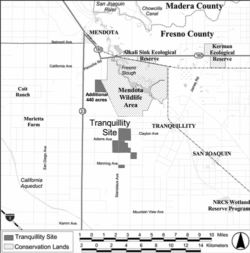
1. Tranquillity Site
In the fall of 1998, the Land Retirement Team purchased 1,646 acres in western Fresno County. An additional 440 acres were added to that site in late 2001 bringing the total to 2,086 acres (Figure 2). An additional 541 acres are currently in escrow and should be added to the site in 2002. Much of the land initially purchased in 1998 had previously been in agricultural production. In 1999, a cover crop of barley was planted on approximately 1,200 acres for weed and erosion control. The remaining acreage had been idled for longer than 5 years and contained sufficient plant cover. The 440 acre parcel obtained in late 2001 has been fallowed and grazed , but has not yet been surveyed for wildlife, or received any restoration efforts. These tasks are scheduled to occur in 2002.

Figure 2.
Current configuration of the Tranquillity site.
2. Atwell Island Site
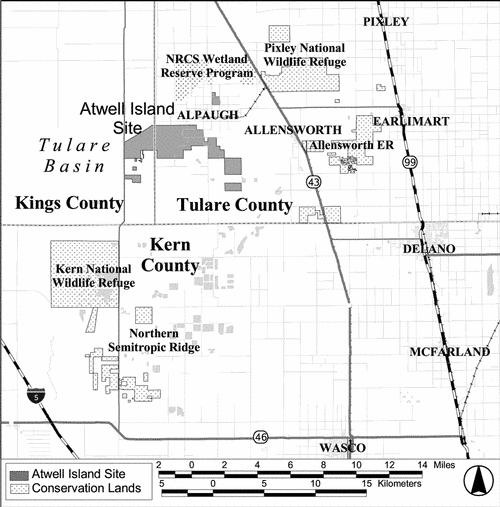
As of February 2002, 4,028 acres had been purchased in Kings and Tulare counties in the Tulare Basin area near Alpaugh (Figure 3). This includes 1,382 acres acquired during 2001. Approximately 2,100 additional acres are currently in escrow and should be acquired in the near future, bringing the Atwell Island project area total acquired to approximately 6,128 acres. The project is authorized to increase to 8,000 acres. Of the 4,028 acres now owned by USBLM, approximately 1,300 acres are currently being farmed, 1,300 acres have not been farmed for 5 years, and 1,400 acres have not been farmed for 15 years. Surveys conducted by ESRP in 1998 indicated that several sensitive species inhabit or use some idled lands that have been purchased at this site (Uptain et al. 1998).

Figure 3.
Current configuration of the Atwell Island site.
D. Project scope
The desired outcome for retired agricultural land is drainage reduction and the reestablishment of self-sustaining upland communities such as California prairie, Valley Sink Scrub, and Valley Saltbush Scrub ( sensu Holland 1986). Because virtually no information is available on upland community restoration of retired agricultural land in the Valley, this Land Retirement Demonstration Project provides an opportunity to develop cost-effective restoration techniques and study the effects of habitat restoration prior to implementation on a larger scale.
A variety of research, monitoring, restoration, and management activities have been implemented on retired lands at both the Tranquillity and the Atwell Island sites since 1999. Some of these activities include:
- a study to determine the responses of wildlife to restoration efforts (Habitat Restoration Study);
- site-wide monitoring of wildlife;
- monitoring of groundwater levels and groundwater quality in relation to reduction of applied irrigation water;
- restoration-related experimentation to gather information on appropriate uses and types of cover crops, seeding rates, seeding methods, seedling planting, microtopographic relief, and mycorrhizal inoculation;
- installation of nurseries to grow locally collected seed;
- implementation of wildlife-friendly farming practices, and;
- management of lands for recreational use.
The following sections of this report describe the accomplishments and preliminary results obtained by the Land Retirement Team in the calendar year 2001. Study designs and methodologies are presented whenever necessary for clarity or when changes have been made from those previously reported.