Endangered Species Recovery Program | |
|
Home | News | Publications | Species profiles | Data and maps | About | Staff | Links | Department of Biological Sciences | CSU Stanislaus |
Recovery Plan for Upland Species of the San Joaquin Valley, California
Contents
. Introduction
. Species accounts
. Recovery
. Stepdown
. Implementation
. References
. Appendix
4. Ecosystem-Level Recovery Strategy
Approach to Recovery Planning.-- As with many other Federal land-management agencies, the USFWS has adopted an ecosystem approach in managing our Nations natural resources (USFWS 1994b, Henne 1995, USFWS 1995a). Given the increasingly severe constraints -- environmental, financial, temporal, political, practical, and other -- of single-species conservation efforts, consideration of a broader, ecosystem approach to conservation has gained much wider attention in recent years (Salwasser 1991, Costanza et al. 1992, Grumbine 1992, Franklin 1993, Jensen et al. 1993, Scott et al. 1993, Slocombe 1993, Tasse 1993, Wilcove 1993, Alverson et al. 1994, Bormann et al. 1994, Grumbine 1994a, 1994b, Jensen and Bourgeron 1994, Noss and Cooperrider 1994, Soulé 1994, Alpert 1995, Ecological Society of America 1995a, 1995b, Kerr 1995, Keystone Center 1991, National Research Council 1995, Noss et al. 1995, Pastor 1995, Tear et al. 1995, Walker 1995, Yaffee et al. 1996).
The ecosystem approach is not, however, without problems and critics (LaRoe 1993, Eisner et al. 1995, Stanley 1995, Wilcove and Blair 1995). Although the ecosystem approach suggests a more simplistic and holistic process for conserving listed species, this approach must still atten to the management and monitoring requirements of key species in the ecosystem to ensure that the ecosystem maintains its integrity -- its constituent species and dynamics -- and continues to support those species that are most vulnerable to ecosystem change. Though there indeed are many advantages to an ecosystem approach, both the State and Federal endangered species acts still require recovery of individually listed species.
In concert with the evolution of the ecosystem management concept, adaptive management has become a somewhat common theme in the conservation literature (Holling 1978, Lee and Lawrence 1986, Walters 1986, Walters and Holling 1990, Boyce 1992 and 1993, Noss and Cooperrider 1994). Adaptive management is the "process of linking management with monitoring within a research framework" (Noss and Cooperrider 1994, p. 298). It is learning by doing, and ongoing monitoring and research are important to learning how to efficiently and sensitively manage ecosystems. Such research will include population viability analyses of umbrella species (listed species with the broadest geographic ranges and habitat requirements), keystone species (those which by their numbers or activities have key roles in shaping the species composition or physical structure of the natural community), and indicator species (species whose presence symbolizes certain features of a natural community). Boyce (1992, 1993, p. 525) considers such analyses, if done properly, a natural extension of adaptive management. Population viability analyses require that all available data on a target species be pulled together to build a simulation model, a model that constitutes a synthesis of our current understanding of the target species population. Population viability analyses can then be used to develop hypotheses about how a particular environmental event (e.g., flood, fire) or a new management scenario would affect a target species population. In this way, population viability analyses can guide the direction of management. This approach could help direct the recovery of some key species in the San Joaquin Valley.
The planning area addressed in this recovery plan (Figure 4; key to numbered locations is in Table 3)--the San Joaquin Valley, Carrizo and Elkhorn Plains, and parts of the Cuyama, Salinas, Sacramento, and other valleys--is a "focus area" in the USFWS Central Valley of California/San Francisco Bay and South Pacific Coast ecosystem units (USFWS 1995a). However, this focus area differs in a number of significant ways from lands addressed in other ecosystem-level conservation efforts. Those efforts generally involve millions of acres of publicly-owned lands, often with large expanses of wilderness (e.g., Clark and Zaunbrecher 1987, Everett et al. 1994).
Of the 45,500 square kilometers (17,500 square miles) in the planning area, exclusive of the Salinas and Pajaro watersheds, only about 2,600 square kilometers (1,000 square miles) are in public and conservation ownership, about 5.7 percent. This contrasts dramatically with other ecosystem efforts throughout the west and with land ownership in other parts of California. The San Joaquin Valley has much more land in private ownership than any of Californias nine other bioregions. Most of the landscape, 95 percent or more, has been altered from its natural state and replaced by irrigated agriculture, cities and towns, and industrial developments. Within this human-shaped mosaic are sparsely scattered remnants of natural communities, all of which have been severely degraded, altered, and fragmented by human activities. One of the most basic and prominent of ecosystem features on the San Joaquin Valley floor--seasonal flooding by winter storms and snowmelt in the towering Sierra Nevada--has been nearly eliminated by the dams, reservoirs, pumps, diversion channels, and canals that capture its waters for use by agriculture and municipalities, some utside its boundaries. All the natural communities shaped and maintained by seasonal runoff no longer function normally, which has led to their endangerment.
This recovery plan acknowledges that if recovery is to be achieved, it must take place within the constraints of the existing human-dominated ecosystem. Trust, partnership, and common purpose must be established amongst government agencies, ranchers, farmers, developers, conservationists, urbanites, and other citizens of the Valley.
If implemented, the outcome of this planning effort most probably will retain the advantages of ecosystem-level conservation: involving all segments of society in recovery actions; preserving all or most species simultaneously; saving effort and money; and increasing the chances that recovery efforts will succeed.
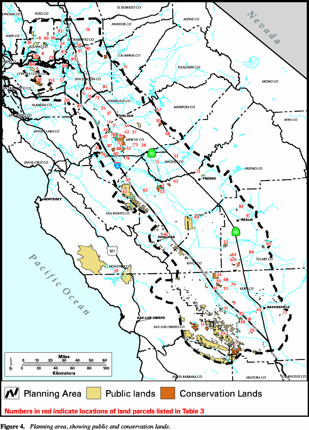
Figure 4. Planning area, showing public and conservation lands
Table 3. Key to Public and Conservation Land Parcels Shown in Figure 4. (Names in bold are those lands which have value to the species covered in theis reovery plan. This list is not complete.)
| Name | Map Number |
|---|---|
| Acker Island | 1 |
| Alkali Sink Ecological Reserve | 2 |
| Allensworth Ecological Reserve | 3 |
| Antioch Dunes National Wildlife Refuge | 4 |
| Banta-Carbona Fish Screen | 5 |
| Barker Slough | 6 |
| Bitter Creek National Wildlife Refuge | 7 |
| Brannon Island Fishing Access | 8 |
| Buttonwillow | 9 |
| Calhoun Cut Ecological Reserve | 10 |
| Camp Roberts Military Reserve | 11 |
| Carrizo Plains Ecological Reserve | 12 |
| Caswell Memorial | 13 |
| China Island | 14 |
| Chowchilla Canal Bypass | 15 |
| Claus | 16 |
| Clifton Court Forebay Wildlife Area | 17 |
| Coles Levee Ecosystem Preserve | 18 |
| Consumnes River | 19 |
| Corral Hollow Ecological Reserve | 20 |
| Cottonwood Creek (Upper & Lower) | 21 |
| Creighton Ranch Preserve | 22 |
| Delta Islands | 23 |
| Delta Meadows | 24 |
| Dos Amigos Mitigation Area | 25 |
| Duck Creek Conservation Easement | 26 |
| Duck Pond | 27 |
| East Gallo | 28 |
| Elk Hills | 29 |
| Elkhorn Plains Ecological Reserve | 30 |
| Flying M Ranch | 31 |
| Freitas | 32 |
| Fresno River | 33 |
| Goose Lake | 34 |
| Grasslands State Park | 35 |
| Grayson-San Joaquin River Cone | 36 |
| Grizzly Island | 37 |
| Hailwood | 38 |
| Hill Slough Wildlife Area | 39 |
| Hunter Liggett Military Reserve | 40 |
| Jepson Prairie | 41 |
| Kaweah Oaks Preserve | 42 |
| Kelly | 43 |
| Kerman Ecological Reserve | 44 |
| Kern National Wildlife Refuge | 45 |
| Kern River Parkway | 46 |
| Kesterson National Wildlife Refuge | 47 |
| Kesterson Site | 48 |
| Le Grand | 49 |
| Lemoore Naval Air Station | 50 |
| Little Panoche Reservoir Wildlife Area | 51 |
| Lokern Preserve | 52 |
| Los Banos Wildlife Management Area | 53 |
| Los Vaqueros Reservoir Conservation Easement | 54 |
| Lost Slough | 55 |
| Mendota Wildlife Management Area | 56 |
| Merced National Wildlife Refuge | 57 |
| Merced River Fish Facility | 58 |
| Mount Diablo State Park | 59 |
| Northern Semi-Tropic Ridge | 60 |
| O'Neill Forebay Wildlife Management Area | 61 |
| Paine Preserve | 62 |
| Panoche Hills Ecological Reserve | 63 |
| Pilibos Mitigation Area | 64 |
| Pixley National Wildlife Refuge | 65 |
| Pixley National Wildlife Refuge | 66 |
| Pixley Vernal Pools Preserve | 67 |
| Pleasant Valley | 68 |
| Poso Creek Conservation Easement at Semi-Tropic Ridge | 69 |
| Rhode Island Delta Riparian Habitat | 70 |
| Salt Slough | 71 |
| Salt Spring Conservation Easement | 72 |
| San Joaquin River National Wildlife Refuge | 73 |
| San Joaquin Ecological Reserve | 74 |
| San Luis Canal Mitigation Area | 75 |
| San Luis National Wildlife Refuge | 76 |
| San Luis Reservoir Wildlife Area | 77 |
| Sandridge Preserve | 78 |
| Schwab | 79 |
| Semi-Tropic Ridge | 80 |
| Sherman Island Waterfowl Management Area | 81 |
| Stanislaus River (Lower) | 82 |
| Stone Corral Ecological Reserve | 83 |
| Sycamore Island Conservation Easement | 84 |
| Tracy Hills | 85 |
| Tule Elk State Reserve | 86 |
| Vernalis Riparian Habitat Corridor | 87 |
| Volta Wildlife Management Area | 88 |
| West Gallo | 89 |
| White Slough Wildlife Management Area | 90 |
| White Slough Wildlife Management Area | 91 |
| Woodbridge Ecological Reserve | 92 |
| Yaudanchi Ecological Refuge | 93 |
| Yolo Basin Conservation Easement | 94 |
![]()